 Skip to content


Visit the Tombs of Menjez, Akkar – Complete Guide to Lebanon’s Largest Megalithic Necropolis
Hidden in the northern hills of Lebanon, just a short distance from the Syrian border, the Tombs of Menjez in Akkar form one of the most remarkable and least-visited archaeological sites in the country. This prehistoric necropolis holds the largest concentration of megalithic tombs in Lebanon and ranks among the most significant in the eastern Mediterranean.
Dating back to the Chalcolithic and Early Bronze Age (roughly 4000–2500 BCE), these basalt structures offer a rare glimpse into the lives, beliefs, and burial practices of early communities in the northern Levant. If you are looking for an authentic, off-the-beaten-path experience that combines history, nature, and culture, the Tombs of Menjez deserve a place on your itinerary.
Quick Overview
- Location: Menjez village, Akkar Governorate, northern Lebanon (approx. 130–140 km from Beirut)
- Period: Chalcolithic to Early Bronze Age (4th–3rd millennium BCE)
- Number of tombs: Originally over 100; 87 recorded in the 1960s; around 40–50 still visible today
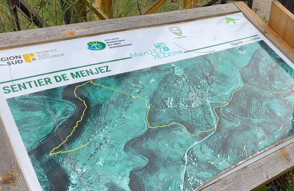
- Accessible trail: 11 restored and protected monuments on a marked discovery path
- Heritage House: Exhibition and visitor center with models, films, and information
- Best for: History lovers, hikers, photography, and cultural travelers seeking lesser-known sites
What Are the Tombs of Menjez?
The tombs of Menjez are above-ground megalithic burial chambers constructed from large local basalt slabs. Chambers vary in shape — circular, oval, rectangular, or polygonal — and are typically small (often under 2 meters in diameter). Many feature an access corridor, usually oriented south, and some stand on platforms or within larger stone enclosures (kerbs).
These monuments were built by agro-pastoral communities who invested significant communal effort in creating lasting resting places for their dead. The deceased were placed directly on stone pavements, accompanied by pottery, ornaments, and offerings. Some stones bear engraved signs, cupules, and notable serpent motifs, adding a layer of symbolic and ritual meaning.
Father Maurice Tallon, a Jesuit scholar, first systematically recorded and excavated many of the tombs between the late 1950s and 1960s. Later research by archaeologist Tara Steimer-Herbet and ongoing projects (including the MEG-A project) have refined dating, architectural analysis, and conservation efforts. Today the site forms part of Lebanon’s tentative UNESCO World Heritage list as part of the historic and natural monuments of Menjez.
What You Can Experience
A well-marked Discovery Trail (also called the Dolmen Tour) allows visitors to explore 11 cleaned and protected tombs set in the basalt landscape around the village. The walk is relatively easy to moderate and can be done independently or with a local guide. You will see different architectural types, standing orthostats averaging about 1.6 meters high, and the surrounding natural environment of wadis and hills.
At the Menjez Heritage House, an exhibition titled “Memories in the Rock, Mankind’s Memories” provides context through panels, films, models, and replicas of artefacts. It explains how and why these monuments were built and offers insights into daily life around 6,000 years ago. Workshops for groups and schools (pottery, flint engraving, etc.) are sometimes available upon reservation.
The wider village of Menjez adds further interest: traditional houses built from black volcanic stone, the Roman-era basalt temple of Maqam el-Rabb (Beit Jaalouk — the only known Roman temple in Lebanon constructed primarily of basalt), remains of a Crusader castle (Felicium), and historic churches.

Hiking at the Tombs of Menjez, Akkar
Menjez offers rewarding and accessible hiking that beautifully combines ancient history with the natural landscapes of northern Lebanon’s Akkar region.
The main highlight is the Menjez Dolmen / Discovery Trail, a short and easy guided or self-guided loop of approximately 3–5 km. This mostly flat path takes you past 11 carefully preserved megalithic tombs set among black basalt rock and open countryside. It is ideal for families, history enthusiasts, and anyone seeking a gentle walk lasting 2–3 hours. Along the way you enjoy views toward the Nahr el-Kabir river and the Syrian border.
For those wanting a bit more distance, local organized hikes typically offer two popular options:
- An easy trail of around 6 km
- A moderate trail of approximately 8.5–9 km
These routes wind through the traditional basalt-stone village, sections of the Black Forest (Horsh el-Assouad), riverside paths, and cultural landmarks such as the Roman temple of Maqam el-Rabb, historic churches, and Crusader ruins. Many end with panoramic viewpoints overlooking northern Lebanon and into Syria. The scenery mixes volcanic rock, green hills, forests, and open farmland, creating a distinctive and peaceful atmosphere rarely found on more crowded Lebanese trails.
The terrain is generally straightforward with mild elevation changes, making most routes suitable for walkers of average fitness. Sturdy shoes are recommended due to uneven surfaces. Spring and autumn provide the best conditions, with pleasant temperatures and greener surroundings.
Whether you choose the short cultural loop focused on the 6,000-year-old tombs or a longer nature-and-heritage hike, Menjez delivers an authentic, low-key outdoor experience far from the usual tourist routes.
Practical Information
Opening Hours
- Discovery Trail: Accessible year-round, 24/7
- Heritage House: Saturdays and Sundays 10:00–18:00 (April to October); Wednesday–Sunday during school vacations; available year-round by reservation
Entrance Fees (as listed by the official site; note that Lebanese Lira values fluctuate — expect very modest fees in practice)
- Heritage House entry: symbolic low fee per person
- Guided Heritage House tour (groups, upon reservation): modest additional fee
- Combined guided Heritage House + walking tour: slightly higher
- Trail itself is free
Recommended Visit Duration
1.5 to 3 hours for the trail and Heritage House. Add more time if combining with other village sites or a short hike.
Facilities
Basic visitor facilities at the Heritage House. The trail is outdoors on uneven terrain — wear sturdy shoes. Limited shade and services in the immediate area; bring water, sun protection, and snacks.
Best Time to Visit and Tips
Spring (March–May) and autumn (September–November) offer the most pleasant weather and green landscapes. Summer can be hot; winters are cooler with possible rain. Early morning or late afternoon provides better light for photography and fewer people.
Practical tips:
- The outdoor trail requires no ticket and can be explored freely.
- Contact the Heritage House or Menjez municipality in advance for guided tours or group visits.
- Respect the monuments — do not climb on or move stones.
- Combine your visit with the Roman temple and panoramic viewpoints for a fuller day.
- Mobile signal may be limited; download offline maps.

How to Get to the Tombs of Menjez
Menjez lies approximately 130–140 km north of Beirut in the Akkar hills, near the Nahr el-Kebir river and the Syrian border.
- By car: The most practical option. Drive north via the coastal highway toward Tripoli, then inland through Akkar. Navigation apps work well; allow 2–2.5 hours from Beirut depending on traffic.
- Public transport: Possible but less convenient — buses or shared taxis to Qobayat or other Akkar towns, followed by a local taxi to Menjez.
- Parking is generally available near the village center or trail starting points.
Nearby Attractions, Food & Accommodation
In Menjez itself you can see the Roman temple, Crusader ruins, St. Daniel’s Church, and traditional basalt architecture. The surrounding Akkar region offers rivers, forests (including El-Horsh El-Assouad), and rural landscapes.
Dining options are limited in the village; many visitors arrange traditional meals with local families or head to nearby towns such as Qobayat. For overnight stays, look for simple guesthouses or hotels in the broader Akkar area or return to Tripoli or the coast.
Frequently Asked Questions
Are the tombs free to visit?
The outdoor discovery trail is free and open at all times. A small fee applies for the Heritage House.
How many tombs can I see?
Eleven monuments are prepared and marked on the official trail. Additional tombs exist in the wider area, some on private land.
Is a guide necessary?
Not required, but recommended for deeper historical context. Local cultural animators can lead tours upon reservation.
Is the site suitable for children or people with limited mobility?
The trail involves uneven ground and mild slopes. The Heritage House is more accessible.
Why are these tombs important?
They represent the largest megalithic necropolis in Lebanon and provide rare evidence of prehistoric burial practices, architecture, and possible ritual symbolism (including serpent imagery) in the northern Levant.
Plan Your Visit to This Hidden Treasure
The Tombs of Menjez offer a powerful connection to Lebanon’s deep prehistoric past in a quiet, authentic setting far from the usual tourist circuits. Whether you come for the archaeology, the landscape, or the sense of discovery, this site rewards those willing to venture into Akkar.
For the latest details on hours, guided tours, or special events, check the official Menjez Heritage resources or contact the municipality. Respect the monuments, support the local community, and take time to absorb the silence of these ancient stones — they have stood for more than five millennia.
Have you visited Menjez or other megalithic sites in the Levant? Share your experiences or questions in the comments. Safe travels!

